
Changes are coming to NJ State Atlas! Check back throughout Winter 2014-2015 for updates as the site is relaunched with new material for New Jersey.
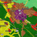
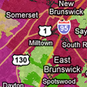 The State Plan Map is an interactive version of the New Jersey State Plan Planning Areas, Centers, Smart Growth Areas and Main Street New Jersey towns. Clicking on the map will bring up information on the planning areas selected. Find out if your address is in a "smart growth" area!
 View the Geography of Luck, twenty years of NJ Lottery winners mapped by ZIP Code. View total winners, amount won, and distribution of winners throughout the state and country.
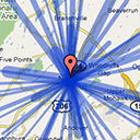 Journey to Work - Plot communting trends between New Jersey municipalities. Based off of Census geometries and DOT's CTPP data.
 Parcel Viewer - I've been trying out some different ways of bringing real property data ("parcels") on to the web. Sure, plenty of counties have a crufty old ArcIMS instance sluggishly serving up parcels. How many of them incorporate the boundaries into Virtual Earth's "bird's eye" view? Check out GlassboroMap.com, a demo of how parcel viewers should work.
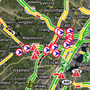 Traffic & Cameras - Another one of our mapping applications features Google's Traffic layer, along with a point layer on incidents reported on NJCommuter.com, NJDOT's real-time traffic site. You can also view NJDOT's traffic cameras from the map.
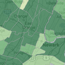
 Pinelands Maps - The Pinelands Comprehensive Management Plan Land Capability Map establishes nine land use management areas with goals, objectives, development intensities and permitted uses for each. The Ecological Integrity Assessment is an evaluation of the landscape and watershed conditions within the Pinelands area.
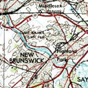 USGS Topo Maps - After a free topographic map viewer was bought and made less user-friendly, I put together this simple mashup using Google Maps and the topo DRGs available from Terraserver.
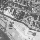 1930s Aerial Photography is available from the State of New Jersey. View it here in a Google Maps mashup.
US Counties - an interactive map of the counties in the US. GIS Data is from the Census Bureau. Clicking on a county will bring up links to other repositories of data.
Campus Map - a Google Maps-based demo of a new Campus Map for Rowan University.
National Grid Map - Demonstration map showing off the US National Grid. The Grid was developed to create a more interoperable environment for location-based services within the United States. The USNG is an established, nationally consistent grid reference system and can be easily extended for use world-wide as a universal grid reference system.
ArcMap + Bird's Eye - I wrote a custom tool in ArcMap that will load this page with the coordinates of the point you click. The page will then load the "bird's eye" view, if available. I'll clean up and post the VBA to make the tool soon.
Municipal Profiles - An entirely database-driven page. Choose a municipality and have several tables worth of information about that municipality returned to you. Despite it being a work in progress, it has plenty of information as well as maps showing the selected municipality's boundaries.
This Website is a side project of John Reiser's. If you're interested in mapping, open government, and freedom of information, you should get in touch with John.
Provide feedback on this site.